
Karns topographic map
Interactive map
Click on the map to display elevation.
About this map
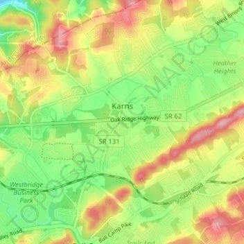
Name: Karns topographic map, elevation, terrain.
Average elevation: 314 m
Minimum elevation: 246 m
Maximum elevation: 394 m
Karns is located in the Beaver Creek Valley between Beaver Ridge and Copper Ridge, both of which are elongate ridges typical of the Ridge-and-Valley Appalachians. The center of the community is located at 35°58′55″N 84°06′50″W / 35.98194°N 84.11389°W / 35.98194; -84.11389 (35.982, -84.114). Elevation ranges from about 960 to 1,000 feet (300 m) above sea level. Beaver Creek, a tributary of the Clinch River, flows through the community.
Other topographic maps
Click on a map to view its topography, its elevation and its terrain.
Knoxville
United States > Tennessee > Knox County
Knoxville, Knox County, East Tennessee, Tennessee, United States
Average elevation: 307 m
Arminda
United States > Tennessee > Knox County
Arminda, Knox County, East Tennessee, Tennessee, 37924, United States
Average elevation: 294 m
University of Tennessee
United States > Tennessee > Knox County > Knoxville
University of Tennessee, Knoxville, Knox County, East Tennessee, Tennessee, United States
Average elevation: 272 m
Knoxville
United States > Tennessee > Knox County > Knoxville
Knoxville, Knox County, Tennessee, 37996-4134, United States
Average elevation: 304 m
Farragut
United States > Tennessee > Knox County
Farragut, Knox County, East Tennessee, Tennessee, 37934, United States
Average elevation: 281 m
Buffat Heights
United States > Tennessee > Knox County > Knoxville
Buffat Heights, Knoxville, Knox County, East Tennessee, Tennessee, 37914, United States
Average elevation: 303 m
Seven Islands State Birding Park
United States > Tennessee > Knox County
Seven Islands State Birding Park, Kelly Lane, Seven Islands, Knox County, East Tennessee, Tennessee, 37764, United States
Average elevation: 280 m
Shooks
United States > Tennessee > Knox County
Shooks, Knox County, East Tennessee, Tennessee, United States
Average elevation: 293 m
Ijams Nature Center
United States > Tennessee > Knox County > Knoxville
Ijams Nature Center, Alamo Avenue Southeast, Knoxville, Knox County, East Tennessee, Tennessee, 37920, United States
Average elevation: 268 m
Graveston
United States > Tennessee > Knox County
Graveston, Knox County, East Tennessee, Tennessee, 37721, United States
Average elevation: 354 m
Heather Heights
United States > Tennessee > Knox County
Heather Heights, Knox County, East Tennessee, Tennessee, 37931, United States
Average elevation: 318 m
Vestal
United States > Tennessee > Knox County > Knoxville
Vestal, Knoxville, Knox County, Tennessee, 37920, United States
Average elevation: 284 m
Powell
United States > Tennessee > Knox County
Powell, Knox County, East Tennessee, Tennessee, 37849, United States
Average elevation: 329 m
House Mountain
United States > Tennessee > Knox County
House Mountain, Knox County, Tennessee, 37806, United States
Average elevation: 396 m
Ten Mile
United States > Tennessee > Knox County > Knoxville
Ten Mile, Knoxville, Knox County, Tennessee, 37923, United States
Average elevation: 291 m
Farrington
United States > Tennessee > Knox County
Farrington, Knox County, Tennessee, 37922, United States
Average elevation: 288 m
Dante
United States > Tennessee > Knox County > Knoxville > Dante
Dante, Knoxville, Knox County, Tennessee, 37912, United States
Average elevation: 332 m
Highland Park
United States > Tennessee > Knox County > Knoxville > Highland Park
Highland Park, Knoxville, Knox County, Tennessee, 37918, United States
Average elevation: 341 m
Garland
United States > Tennessee > Knox County > Garland
Garland, Knox County, Tennessee, 37922, United States
Average elevation: 264 m
Ijams Nature Center
United States > Tennessee > Knox County > Knoxville
Ijams Nature Center, Knoxville, Knox County, Tennessee, United States
Average elevation: 268 m
Arlington
United States > Tennessee > Knox County > Knoxville > Arlington
Arlington, Knoxville, Knox County, Tennessee, 37917, United States
Average elevation: 310 m
Audubon Hills
United States > Tennessee > Knox County > Farragut > Audubon Hills
Audubon Hills, Farragut, Knox County, Tennessee, 37934, United States
Average elevation: 270 m
Riverbend
United States > Tennessee > Knox County > Riverbend
Riverbend, Knox County, Tennessee, 37919, United States
Average elevation: 267 m
Mascot
United States > Tennessee > Knox County
Mascot, Knox County, East Tennessee, Tennessee, 37806, United States
Average elevation: 290 m
Island Home
United States > Tennessee > Knox County > Knoxville > Island Home
Island Home, Knoxville, Knox County, Tennessee, 37914:37915, United States
Average elevation: 276 m
Valley Grove
United States > Tennessee > Knox County > Valley Grove
Valley Grove, Knox County, Tennessee, 37865, United States
Average elevation: 325 m
Corryton
United States > Tennessee > Knox County
Corryton, Knox County, East Tennessee, Tennessee, 37779, United States
Average elevation: 319 m
Summit Hill
United States > Tennessee > Knox County > Knoxville
Summit Hill, Knoxville, Knox County, Tennessee, 37902, United States
Average elevation: 278 m