
Auburn topographic map
Interactive map
Click on the map to display elevation.
About this map
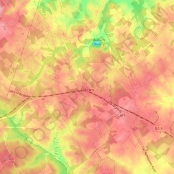
Name: Auburn topographic map, elevation, terrain.
Location: Auburn, Barrow County, Georgia, 30011, United States (33.98021 -83.86523 34.04937 -83.79528)
Average elevation: 300 m
Minimum elevation: 221 m
Maximum elevation: 339 m
Other topographic maps
Click on a map to view its topography, its elevation and its terrain.
Fort Yargo State Park
United States > Georgia > Barrow County > Winder
Fort Yargo State Park, Winder, Barrow County, Georgia, United States
Average elevation: 270 m
Statham
United States > Georgia > Barrow County
Statham, Barrow County, Georgia, United States
Average elevation: 261 m
Carl
United States > Georgia > Barrow County
Carl, Barrow County, Georgia, United States
Average elevation: 317 m
Russell
United States > Georgia > Barrow County
Russell, Barrow County, Georgia, 30680, United States
Average elevation: 279 m
Bethlehem
United States > Georgia > Barrow County
Bethlehem, Barrow County, Georgia, United States
Average elevation: 258 m
Winder
United States > Georgia > Barrow County
Winder, Barrow County, Georgia, United States
Average elevation: 274 m