Geolocate

Carl topographic map

Interactive map

Click on the map to display elevation.

About this map

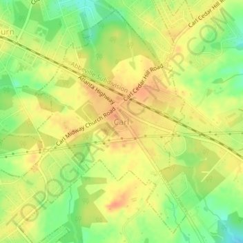
Name: Carl topographic map, elevation, terrain.

Location: Carl, Barrow County, Georgia, United States (33.99121 -83.82909 34.01609 -83.80222)

Average elevation: 317 m

Minimum elevation: 292 m

Maximum elevation: 333 m

Other topographic maps

Click on a map to view its topography, its elevation and its terrain.

Fort Yargo State Park

United States > Georgia > Barrow County > Winder

Fort Yargo State Park, Winder, Barrow County, Georgia, United States

Average elevation: 270 m

Auburn

United States > Georgia > Barrow County

Auburn, Barrow County, Georgia, 30011, United States

Average elevation: 300 m

Statham

United States > Georgia > Barrow County

Statham, Barrow County, Georgia, United States

Average elevation: 261 m

Russell

United States > Georgia > Barrow County

Russell, Barrow County, Georgia, 30680, United States

Average elevation: 279 m

Bethlehem

United States > Georgia > Barrow County

Bethlehem, Barrow County, Georgia, United States

Average elevation: 258 m

Winder

United States > Georgia > Barrow County

Winder, Barrow County, Georgia, United States

Average elevation: 274 m