
Mariaberg topographic map
Interactive map
Click on the map to display elevation.
About this map
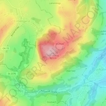
Name: Mariaberg topographic map, elevation, terrain.
Location: Mariaberg, Kempten (Allgäu), Bayern, 87487, Deutschland (47.71822 10.26414 47.71832 10.26424)
Average elevation: 807 m
Minimum elevation: 718 m
Maximum elevation: 924 m
Other topographic maps
Click on a map to view its topography, its elevation and its terrain.
Leupolz
Deutschland > Bayern > Kempten (Allgäu)
Leupolz, Kempten (Allgäu), Bayern, 87437, Deutschland
Average elevation: 726 m
Schatten
Deutschland > Bayern > Kempten (Allgäu) > Schatten
Schatten, Kempten (Allgäu), Bayern, Deutschland
Average elevation: 725 m
Leupratsried
Deutschland > Bayern > Kempten (Allgäu)
Leupratsried, Kempten (Allgäu), Bayern, Deutschland
Average elevation: 715 m
Tannen
Deutschland > Bayern > Kempten (Allgäu)
Tannen, Kempten (Allgäu), Bayern, 87437, Deutschland
Average elevation: 743 m
Stoffels
Deutschland > Bayern > Kempten (Allgäu) > Stoffels
Stoffels, Kempten (Allgäu), Bayern, 87487, Deutschland
Average elevation: 796 m
Hub
Deutschland > Bayern > Kempten (Allgäu) > Leubas > Hub
Hub, Leubas, Kempten (Allgäu), Bayern, 87493, Deutschland
Average elevation: 696 m
87435
Deutschland > Bayern > Kempten (Allgäu)
87435, Franzosenbauer, Kempten (Allgäu), Bayern, Deutschland
Average elevation: 722 m
Unterwang
Deutschland > Bayern > Kempten (Allgäu) > Zollhaus > Unterwang
Unterwang, Zollhaus, Kempten (Allgäu), Bayern, Deutschland
Average elevation: 680 m
Kempten (Allgäu)
Deutschland > Bayern > Kempten (Allgäu)
Kempten (Allgäu), Bayern, 87435, Deutschland
Average elevation: 732 m