
Great Basin National Park topographic map
Interactive map
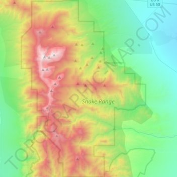
Click on the map to display elevation.
About this map
Name: Great Basin National Park topographic map, elevation, terrain.
Average elevation: 2,352 m
Minimum elevation: 1,566 m
Maximum elevation: 3,938 m
The park derives its name from the Great Basin, the dry and mountainous region between the Sierra Nevada and the Wasatch Mountains. Topographically, this area is known as the Basin and Range Province. The park is located about 290 miles (470 km) north of Las Vegas and protects 77,180 acres (31,230 ha).
Other topographic maps
Click on a map to view its topography, its elevation and its terrain.
Baker
United States > Nevada > White Pine County
Baker, White Pine County, Nevada, 89311, United States
Average elevation: 1,632 m
Lehman Caves
United States > Nevada > White Pine County
Lehman Caves, Lehman Caves Road, White Pine County, Nevada, United States
Average elevation: 2,143 m
Lund
United States > Nevada > White Pine County
Lund, White Pine County, Nevada, 89317, United States
Average elevation: 1,757 m
Red Rocks
United States > Nevada > White Pine County
Red Rocks, White Pine County, Nevada, United States
Average elevation: 1,912 m
Ely
United States > Nevada > White Pine County
Ely, White Pine County, Nevada, 89301, United States
Average elevation: 2,045 m
Mount Moriah
United States > Nevada > White Pine County
Mount Moriah, White Pine County, Nevada, United States
Average elevation: 3,295 m