
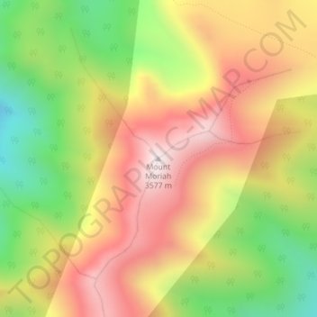
Mount Moriah topographic map
Interactive map
Click on the map to display elevation.
About this map
Name: Mount Moriah topographic map, elevation, terrain.
Location: Mount Moriah, White Pine County, Nevada, United States (39.27317 -114.19888 39.27327 -114.19878)
Average elevation: 3,295 m
Minimum elevation: 2,874 m
Maximum elevation: 3,671 m
Other topographic maps
Click on a map to view its topography, its elevation and its terrain.
Baker
United States > Nevada > White Pine County
Baker, White Pine County, Nevada, 89311, United States
Average elevation: 1,632 m
Lehman Caves
United States > Nevada > White Pine County
Lehman Caves, Lehman Caves Road, White Pine County, Nevada, United States
Average elevation: 2,143 m
Great Basin National Park
United States > Nevada > White Pine County
Great Basin National Park, White Pine County, Nevada, United States
Average elevation: 2,352 m
Lund
United States > Nevada > White Pine County
Lund, White Pine County, Nevada, 89317, United States
Average elevation: 1,757 m
Red Rocks
United States > Nevada > White Pine County
Red Rocks, White Pine County, Nevada, United States
Average elevation: 1,912 m
Ely
United States > Nevada > White Pine County
Ely, White Pine County, Nevada, 89301, United States
Average elevation: 2,045 m