
Gangnam-gu topographic map
Interactive map
Click on the map to display elevation.
About this map
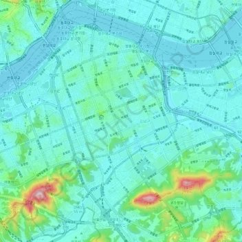
Name: Gangnam-gu topographic map, elevation, terrain.
Location: Gangnam-gu, Seoul, South Korea (37.45648 127.00838 37.53998 127.12273)
Average elevation: 44 m
Minimum elevation: 2 m
Maximum elevation: 284 m
Other topographic maps
Click on a map to view its topography, its elevation and its terrain.
Jeongneung 4(sa)-dong
Jeongneung 4(sa)-dong, Seongbuk-gu, Seoul, Gyeonggi, South Korea, 대성문
Average elevation: 432 m
Seoul
South Korea > Seoul > Eunpyeong-gu
Nokbeon-dong, Eunpyeong-gu, Seoul, South Korea
Average elevation: 77 m