
Jeongneung 4(sa)-dong topographic map
Interactive map
Click on the map to display elevation.
About this map
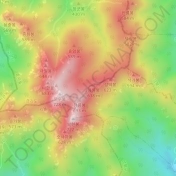
Name: Jeongneung 4(sa)-dong topographic map, elevation, terrain.
Average elevation: 432 m
Minimum elevation: 148 m
Maximum elevation: 698 m
Other topographic maps
Click on a map to view its topography, its elevation and its terrain.
Yongsan-gu
Yongsan is located next to the Han River, with level ground in the west of the district which has been used for transportation (rail) and commercial use since the early 20th century. To the east and north in the land is steeper and rises towards Namsan which lies to the north. Namsan has an elevation of 243m…
Average elevation: 39 m