
Thank you for supporting this site ❤️
Make a donation
Make a donation
Runkst topographic map
Click on the map to display elevation.
Thank you for supporting this site ❤️
Make a donation
Make a donation
About this map
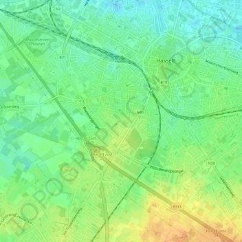
Name: Runkst topographic map, elevation, terrain.
Location: Runkst, Hasselt, Limburg, 3500, België (50.90767 5.27968 50.93514 5.33648)
Average elevation: 43 m
Minimum elevation: 28 m
Maximum elevation: 61 m
Thank you for supporting this site ❤️
Make a donation
Make a donation
Other topographic maps
Click on a map to view its topography, its elevation and its terrain.
Kortessem
België > Limburg > Hasselt > Hasselt
Het dorp ontstond als een driehoekige nederzetting, geflankeerd door de Heerbaan van Hasselt naar Tongeren (tegenwoordig: Mersenhovenstraat), de Klokkenhofsteeg en de (huidige) Dorpsstraat. Van belang is de weg van Hasselt naar Tongeren, welke omstreeks 1740 werd aangelegd (zie: Steenweg op Luik). De…
Average elevation: 53 m