
Thank you for supporting this site ❤️
Make a donation
Make a donation
Manchester Township topographic map
Click on the map to display elevation.
Thank you for supporting this site ❤️
Make a donation
Make a donation
About this map
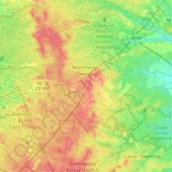
Name: Manchester Township topographic map, elevation, terrain.
Location: Manchester Township, Ocean County, New Jersey, United States (39.85480 -74.49528 40.05588 -74.23154)
Average elevation: 34 m
Minimum elevation: 8 m
Maximum elevation: 63 m
Thank you for supporting this site ❤️
Make a donation
Make a donation
Other topographic maps
Click on a map to view its topography, its elevation and its terrain.
Thank you for supporting this site ❤️
Make a donation
Make a donation
Thank you for supporting this site ❤️
Make a donation
Make a donation
Thank you for supporting this site ❤️
Make a donation
Make a donation
Story Island Channel
United States > New Jersey > Ocean County > Little Egg Harbor Township
Average elevation: 0 m
Barnegat Beach
United States > New Jersey > Ocean County > Ocean Township > Waretown
Average elevation: 4 m
Thank you for supporting this site ❤️
Make a donation
Make a donation