
Thank you for supporting this site ❤️
Make a donation
Make a donation
Bayside Beach topographic map
Click on the map to display elevation.
Thank you for supporting this site ❤️
Make a donation
Make a donation
About this map
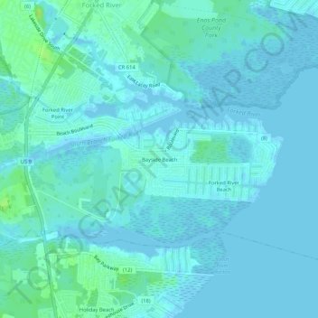
Name: Bayside Beach topographic map, elevation, terrain.
Average elevation: 3 m
Minimum elevation: -4 m
Maximum elevation: 14 m
Thank you for supporting this site ❤️
Make a donation
Make a donation
Other topographic maps
Click on a map to view its topography, its elevation and its terrain.
Forked River
United States > New Jersey > Ocean County > Lacey Township > Forked River
Average elevation: 2 m
Forked River
United States > New Jersey > Ocean County > Lacey Township > Forked River
Average elevation: 2 m