
甘孜县 topographic map
Interactive map
Click on the map to display elevation.
About this map
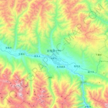
Name: 甘孜县 topographic map, elevation, terrain.
Location: 甘孜县, 甘孜藏族自治州, 四川省, 中国 (31.46804 99.83088 31.78804 100.15088)
Average elevation: 4,171 m
Minimum elevation: 3,297 m
Maximum elevation: 5,669 m
甘孜县(藏文:དཀར་མཛེས་རྫོང་,藏语拼音:Garzê Zong,威利:dkar mdzes rdzong)是中华人民共和国四川省甘孜藏族自治州辖县,位于甘孜州西北部,雅砻江的上游。人口约5.6万,面积约7364平方公里,海拔3325-5688米,辖一镇二十一乡,县政府在甘孜镇。甘孜县中的寺院有:甘孜寺、大金寺、白日寺等。
Other topographic maps
Click on a map to view its topography, its elevation and its terrain.