
Make a donation
Daocheng County topographic map
Click on the map to display elevation.
Make a donation
Daocheng County
Daocheng County or Dapba in Tibetan (Tibetan: འདབ་པ་རྫོང་།; Chinese: 稻城县) is a county of western Sichuan Province, China, located in the eastern Hengduan Mountains. It is under the administration of the Garzê Tibetan Autonomous Prefecture with an overwhelmingly Tibetan population. Its latitude ranges from 27° 58' to 29° 30' N and longitude 99° 56' to 100° 36', and reaches 174 kilometres (108 mi) in north–south extent and 63 km (39 mi) in east–west width, with elevations ranging from 2,000 to 6,032 m (6,562 to 19,790 ft).
Make a donation
About this map
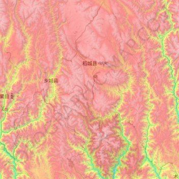
Name: Daocheng County topographic map, elevation, terrain.
Location: Daocheng County, Kardze, Sichuan, 627700, China (27.96542 99.84888 29.70734 100.61317)
Average elevation: 3,926 m
Minimum elevation: 1,962 m
Maximum elevation: 5,922 m
Make a donation
Other topographic maps
Click on a map to view its topography, its elevation and its terrain.
Make a donation
Jiuzhaigou
China > Sichuan > Jiuzhaigou County
The county consists of nine villages in a valley in Sichuan Province. The main ethnic group in the county is Han, with the second being Tibetan. The county seat has an altitude of about 1,400 m (4,600 ft). It has a total area of 2,041 square miles (5,286 km2). As of 2015, the county's total population was…
Average elevation: 2,520 m
Make a donation