
Make a donation
Töging am Inn topographic map
Click on the map to display elevation.
Make a donation
Töging am Inn
Am 30. Juni 2019 gab es in der Stadt 2698 sozialversicherungspflichtige Arbeitsplätze. Von der Wohnbevölkerung standen 3980 Personen in einer versicherungspflichtigen Tätigkeit, so dass die Zahl der Auspendler um 1282 höher war als die der Einpendler. 155 Einwohner waren arbeitslos. Von den 14 landwirtschaftlichen Betrieben wurden im Jahr 2016 insgesamt 457 Hektar bewirtschaftet.
Make a donation
About this map
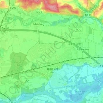
Name: Töging am Inn topographic map, elevation, terrain.
Location: Töging am Inn, Landkreis Altötting, Bayern, 84513, Deutschland (48.23870 12.56088 48.28906 12.62286)
Average elevation: 398 m
Minimum elevation: 365 m
Maximum elevation: 475 m
Make a donation
Other topographic maps
Click on a map to view its topography, its elevation and its terrain.
Make a donation
Aicher
Deutschland > Bayern > Landkreis Altötting > Burgkirchen an der Alz > Pirach
Average elevation: 452 m
Make a donation
Wald an der Alz
Deutschland > Bayern > Landkreis Altötting > Garching an der Alz
Average elevation: 469 m
Make a donation
Thalhausen
Deutschland > Bayern > Landkreis Altötting > Burgkirchen an der Alz > Holzen
Average elevation: 438 m
Hart an der Alz
Deutschland > Bayern > Landkreis Altötting > Garching an der Alz
Average elevation: 460 m
Make a donation
Make a donation
Make a donation
Make a donation
Make a donation