
衢州市 topographic map
Interactive map
Click on the map to display elevation.
About this map
Name: 衢州市 topographic map, elevation, terrain.
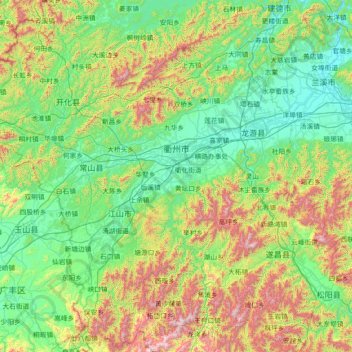
Location: 衢州市, 浙江省, 324207, 中国 (28.24141 118.02241 29.50035 119.34196)
Average elevation: 386 m
Minimum elevation: 18 m
Maximum elevation: 1,634 m
衢州市地质构造属江南古陆南侧,华夏古陆北缘,即跨越两个一级构造单元,中部为钱塘江凹陷地带。总的地势特征为南、北高,中部低,西部高,东部低,中部为浙江省最大的内陆盆地-金衢盆地的西半部,自西向东逐渐展宽。境内平原占15%,丘陵占36%,山地占49%。北部为千里岗山脉,西部为怀玉山脉,南部为市内最大山脉仙霞岭山脉,全市最高点为江山市的大龙岗,海拔1500.3米。最低处为东部的龙游县下童村,海拔33米。
Other topographic maps
Click on a map to view its topography, its elevation and its terrain.