
Oneida topographic map
Interactive map
Click on the map to display elevation.
About this map
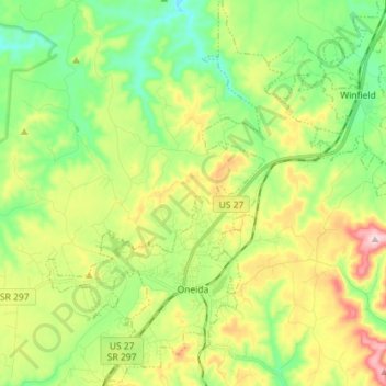
Name: Oneida topographic map, elevation, terrain.
Location: Oneida, Scott County, Tennessee, 37841, United States (36.46935 -84.56706 36.58402 -84.45588)
Average elevation: 447 m
Minimum elevation: 328 m
Maximum elevation: 654 m
Other topographic maps
Click on a map to view its topography, its elevation and its terrain.
Glenmary
United States > Tennessee > Scott County
Glenmary, Scott County, Tennessee, 37852, United States
Average elevation: 422 m
Robbins Park
United States > Tennessee > Scott County > Robbins
Robbins Park, Robbins, Scott County, Tennessee, United States
Average elevation: 438 m
Robbins
United States > Tennessee > Scott County > Robbins
Robbins, Scott County, Tennessee, 37852, United States
Average elevation: 436 m
Huntsville
United States > Tennessee > Scott County
Huntsville, Scott County, East Tennessee, Tennessee, United States
Average elevation: 432 m
Helenwood
United States > Tennessee > Scott County
Helenwood, Scott County, East Tennessee, Tennessee, 37755, United States
Average elevation: 432 m
Winfield
United States > Tennessee > Scott County > Winfield
Winfield, Scott County, Tennessee, 37892, United States
Average elevation: 435 m
Toomy
United States > Tennessee > Scott County > Toomy
Toomy, Scott County, Tennessee, United States
Average elevation: 442 m