
Enterprise topographic map
Interactive map
Click on the map to display elevation.
About this map
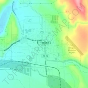
Name: Enterprise topographic map, elevation, terrain.
Location: Enterprise, Wallowa County, Oregon, United States (45.41475 -117.29776 45.43579 -117.26192)
Average elevation: 1,162 m
Minimum elevation: 1,125 m
Maximum elevation: 1,248 m
Other topographic maps
Click on a map to view its topography, its elevation and its terrain.
Big Canyon Fish Weir
United States > Oregon > Wallowa County
Big Canyon Fish Weir, Wallowa County, Oregon, United States
Average elevation: 944 m
Troy
United States > Oregon > Wallowa County
Troy, Wallowa County, Oregon, United States
Average elevation: 711 m
Eagle Cap Wilderness
United States > Oregon > Wallowa County
Eagle Cap Wilderness, Wallowa County, Oregon, United States
Average elevation: 1,629 m
Imnaha
United States > Oregon > Wallowa County > Imnaha
Imnaha, Wallowa County, Oregon, 97842, United States
Average elevation: 861 m
Wallowa
United States > Oregon > Wallowa County > Wallowa
Wallowa, Wallowa County, Oregon, 97885, United States
Average elevation: 937 m
Joseph
United States > Oregon > Wallowa County
Joseph, Wallowa County, Oregon, 97846, United States
Average elevation: 1,285 m