
Balangan topographic map
Interactive map
Click on the map to display elevation.
About this map
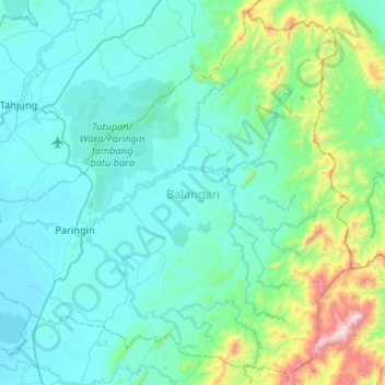
Name: Balangan topographic map, elevation, terrain.
Location: Balangan, South Kalimantan, Indonesia (-2.53239 115.31255 -2.04031 115.83628)
Average elevation: 203 m
Minimum elevation: 5 m
Maximum elevation: 1,565 m
Other topographic maps
Click on a map to view its topography, its elevation and its terrain.
Teluk Karya
Indonesia > South Kalimantan > Balangan
Teluk Karya, Balangan, South Kalimantan, Kalimantan, 71571, Indonesia
Average elevation: 9 m