
Fenoughil topographic map
Interactive map
Click on the map to display elevation.
About this map
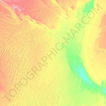
Name: Fenoughil topographic map, elevation, terrain.
Location: Fenoughil, Daïra de Fenoughil, Adrar, 00100, Algérie (27.45316 -2.98301 27.76152 0.59437)
Average elevation: 300 m
Minimum elevation: 120 m
Maximum elevation: 579 m
Other topographic maps
Click on a map to view its topography, its elevation and its terrain.
Ksar Temassekht
Algérie > Adrar > Daïra de Fenoughil
Ksar Temassekht, Tamest, Daïra de Fenoughil, Adrar, Algérie
Average elevation: 235 m
Tamentit
Algérie > Adrar > Daïra de Fenoughil
Tamentit, Daïra de Fenoughil, Adrar, 1038, Algérie
Average elevation: 270 m
Tamest
Algérie > Adrar > Daïra de Fenoughil > Tamest
Tamest, Daïra de Fenoughil, Adrar, 01028, Algérie
Average elevation: 295 m