
Thank you for supporting this site ❤️
Make a donation
Make a donation
Zhangye topographic map
Click on the map to display elevation.
Thank you for supporting this site ❤️
Make a donation
Make a donation
About this map
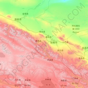
Name: Zhangye topographic map, elevation, terrain.
Location: Zhangye, Gansu, China (37.62649 97.39345 39.88689 102.20450)
Average elevation: 2,659 m
Minimum elevation: 1,027 m
Maximum elevation: 5,693 m
Thank you for supporting this site ❤️
Make a donation
Make a donation
Other topographic maps
Click on a map to view its topography, its elevation and its terrain.