
El Bayadh topographic map
Interactive map
Click on the map to display elevation.
About this map
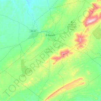
Name: El Bayadh topographic map, elevation, terrain.
Location: El Bayadh, daïra El Bayadh, El Bayadh, Algérie (33.48621 0.85259 33.78887 1.17673)
Average elevation: 1,384 m
Minimum elevation: 1,178 m
Maximum elevation: 2,011 m
Située dans le Djebel Amour, c'est une ville haute en altitude, l'élevage ovin est une activité importante de sa région.
Other topographic maps
Click on a map to view its topography, its elevation and its terrain.
daïra El Bayadh
Algérie > El Bayadh > daïra El Bayadh
daïra El Bayadh, El Bayadh, Algérie
Average elevation: 1,383 m