
daïra El Bayadh topographic map
Interactive map
Click on the map to display elevation.
About this map
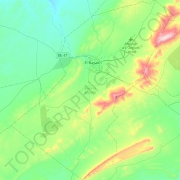
Name: daïra El Bayadh topographic map, elevation, terrain.
Location: daïra El Bayadh, El Bayadh, Algérie (33.48621 0.85259 33.78887 1.17673)
Average elevation: 1,383 m
Minimum elevation: 1,178 m
Maximum elevation: 2,011 m
Other topographic maps
Click on a map to view its topography, its elevation and its terrain.
El Bayadh
Algérie > El Bayadh > daïra El Bayadh
El Bayadh, daïra El Bayadh, El Bayadh, Algérie
Average elevation: 1,384 m