
Silver Lake topographic map
Interactive map
Click on the map to display elevation.
About this map
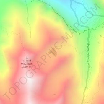
Name: Silver Lake topographic map, elevation, terrain.
Location: Silver Lake, San Miguel County, Colorado, United States (37.91219 -107.78341 37.91460 -107.78068)
Average elevation: 3,459 m
Minimum elevation: 2,768 m
Maximum elevation: 3,998 m
Other topographic maps
Click on a map to view its topography, its elevation and its terrain.
Telluride
United States > Colorado > San Miguel County
Telluride, San Miguel County, Colorado, 81435, United States
Average elevation: 3,125 m
Specie Mesa
United States > Colorado > San Miguel County
Specie Mesa, San Miguel County, Colorado, United States
Average elevation: 2,933 m
Mountain Village
United States > Colorado > San Miguel County
Mountain Village, San Miguel County, Colorado, United States
Average elevation: 2,917 m
Telluride
United States > Colorado > San Miguel County > Telluride
Telluride, San Miguel County, Colorado, 8145, United States
Average elevation: 3,246 m
Norwood
United States > Colorado > San Miguel County > Norwood
Norwood, San Miguel County, Colorado, 81325, United States
Average elevation: 2,148 m
Placerville
United States > Colorado > San Miguel County > Placerville
Placerville, San Miguel County, Colorado, 81430, United States
Average elevation: 2,460 m