
Mountain Village topographic map
Interactive map
Click on the map to display elevation.
About this map
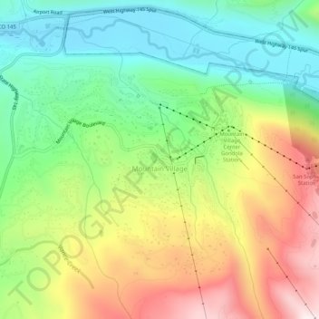
Name: Mountain Village topographic map, elevation, terrain.
Average elevation: 2,917 m
Minimum elevation: 2,629 m
Maximum elevation: 3,341 m
Mountain Village is a home rule municipality in San Miguel County, southwestern Colorado. It is located just southwest of Telluride, Colorado in the San Juan Mountains. The elevation of the town rises above Telluride to 9,600 feet. The population was 1,264 at the 2020 census.
Other topographic maps
Click on a map to view its topography, its elevation and its terrain.
Silver Lake
United States > Colorado > San Miguel County
Silver Lake, San Miguel County, Colorado, United States
Average elevation: 3,459 m
Telluride
United States > Colorado > San Miguel County
Telluride, San Miguel County, Colorado, 81435, United States
Average elevation: 3,125 m
Specie Mesa
United States > Colorado > San Miguel County
Specie Mesa, San Miguel County, Colorado, United States
Average elevation: 2,933 m
Telluride
United States > Colorado > San Miguel County > Telluride
Telluride, San Miguel County, Colorado, 8145, United States
Average elevation: 3,246 m
Norwood
United States > Colorado > San Miguel County > Norwood
Norwood, San Miguel County, Colorado, 81325, United States
Average elevation: 2,148 m
Placerville
United States > Colorado > San Miguel County > Placerville
Placerville, San Miguel County, Colorado, 81430, United States
Average elevation: 2,460 m