
Sanborn topographic map
Interactive map
Click on the map to display elevation.
About this map
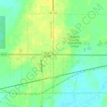
Name: Sanborn topographic map, elevation, terrain.
Average elevation: 193 m
Minimum elevation: 182 m
Maximum elevation: 204 m
Other topographic maps
Click on a map to view its topography, its elevation and its terrain.
City of Lockport
United States > New York > Niagara County
City of Lockport, Niagara County, New York, 14094, United States
Average elevation: 174 m
Town of Lewiston
United States > New York > Niagara County
Town of Lewiston, Niagara County, New York, United States
Average elevation: 134 m
Ransomville
United States > New York > Niagara County
Ransomville, Town of Porter, Niagara County, New York, 14131, United States
Average elevation: 97 m
332
United States > New York > Niagara County > City of Niagara Falls
332, City of Niagara Falls, Niagara County, New York, United States, Niagara Falls State Park
Average elevation: 169 m
Lockport
United States > New York > Niagara County
Lockport, City of Lockport, Niagara County, New York, 14094, United States
Average elevation: 152 m
Town of Wheatfield
United States > New York > Niagara County
Town of Wheatfield, Niagara County, New York, United States
Average elevation: 180 m
Village of Lewiston
United States > New York > Niagara County
Village of Lewiston, Town of Lewiston, Niagara County, New York, United States
Average elevation: 122 m
Village of Middleport
United States > New York > Niagara County
Village of Middleport, Town of Royalton, Niagara County, New York, United States
Average elevation: 156 m
South Lockport
United States > New York > Niagara County
South Lockport, Town of Lockport, Niagara County, New York, United States
Average elevation: 185 m
City of North Tonawanda
United States > New York > Niagara County
City of North Tonawanda, Niagara County, New York, 14120, United States
Average elevation: 177 m
City of Niagara Falls
United States > New York > Niagara County
City of Niagara Falls, Niagara County, New York, United States
Average elevation: 180 m
Village of Wilson
United States > New York > Niagara County
Village of Wilson, Town of Wilson, Niagara County, New York, United States
Average elevation: 84 m
Love Canal
United States > New York > Niagara County > Niagara Falls > Black Creek Village
Love Canal, Love Canal superfund site, Black Creek Village, Niagara Falls, Niagara County, New York, 14304, United States
Average elevation: 176 m
Escarpment
United States > New York > Niagara County > Town of Lewiston > Escarpment
Escarpment, Town of Lewiston, Niagara County, New York, 14092, United States
Average elevation: 156 m
La Salle
United States > New York > Niagara County > Niagara Falls > La Salle
La Salle, Niagara Falls, Niagara County, New York, 14304, United States
Average elevation: 176 m
Rapids
United States > New York > Niagara County > Rapids
Rapids, Town of Lockport, Niagara County, New York, United States
Average elevation: 179 m
Artpark State Park
United States > New York > Niagara County > Lewiston > Lewiston Heights
Artpark State Park, Lewiston Heights, Lewiston, Niagara County, New York, United States
Average elevation: 154 m
Olcott
United States > New York > Niagara County
Olcott, Town of Newfane, Niagara County, New York, United States
Average elevation: 88 m
Village of Youngstown
United States > New York > Niagara County
Village of Youngstown, Town of Porter, Niagara County, New York, United States
Average elevation: 86 m