
Taipei topographic map
Interactive map
Click on the map to display elevation.
About this map
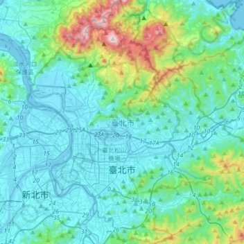
Name: Taipei topographic map, elevation, terrain.
Location: Taipei, Taiwan (24.96052 121.45714 25.21024 121.66594)
Average elevation: 173 m
Minimum elevation: -6 m
Maximum elevation: 1,096 m
Other topographic maps
Click on a map to view its topography, its elevation and its terrain.
Lintou Village
Taiwan > Taiwan Province > Yunlin County > Douliu City
Lintou Village, Douliu City, Yunlin County, Taiwan Province, Taiwan
Average elevation: 61 m
Guizikengshan
Taiwan > Taiwan Province > Nantou County > Yuchi Township
Guizikengshan, Yuchi Township, Nantou County, Taiwan Province, 55547, Taiwan
Average elevation: 675 m
Hualien County
Hualien County, Taiwan Province, Taiwan
Average elevation: 686 m