
Hualien County topographic map
Interactive map
Click on the map to display elevation.
About this map
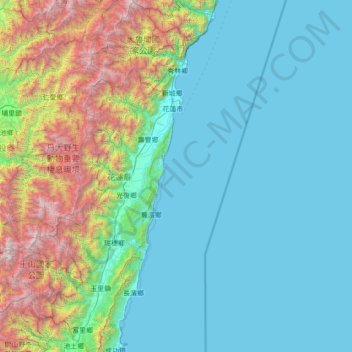
Name: Hualien County topographic map, elevation, terrain.
Location: Hualien County, Taiwan Province, Taiwan (23.09778 120.98660 24.37053 121.77382)
Average elevation: 686 m
Minimum elevation: 0 m
Maximum elevation: 3,857 m
Other topographic maps
Click on a map to view its topography, its elevation and its terrain.
Lintou Village
Taiwan > Taiwan Province > Yunlin County > Douliu City
Lintou Village, Douliu City, Yunlin County, Taiwan Province, Taiwan
Average elevation: 61 m
Guizikengshan
Taiwan > Taiwan Province > Nantou County > Yuchi Township
Guizikengshan, Yuchi Township, Nantou County, Taiwan Province, 55547, Taiwan
Average elevation: 675 m