
West Lawerenctown topographic map
Interactive map
Click on the map to display elevation.
About this map
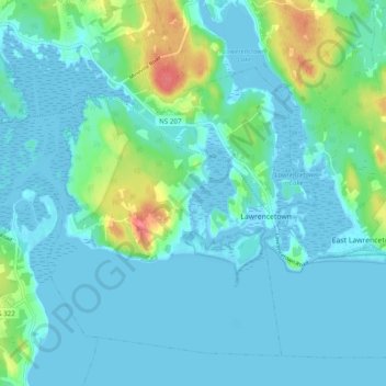
Name: West Lawerenctown topographic map, elevation, terrain.
Location: West Lawerenctown, Lawrencetown, Nova Scotia, Canada (44.62648 -63.44582 44.68508 -63.34798)
Average elevation: 11 m
Minimum elevation: -4 m
Maximum elevation: 64 m
Other topographic maps
Click on a map to view its topography, its elevation and its terrain.
West Lawrencetown
Canada > Nova Scotia > Lawrencetown
West Lawrencetown, Lawrencetown, Municipality of the County of Annapolis, Annapolis County, Nova Scotia, B0S1M0, Canada
Average elevation: 55 m