Geolocate

Asan-si topographic map

Interactive map

Click on the map to display elevation.

About this map

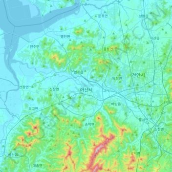
Name: Asan-si topographic map, elevation, terrain.

Location: Asan-si, South Chungcheong, South Korea (36.64865 126.82796 36.94254 127.11967)

Average elevation: 79 m

Minimum elevation: -3 m

Maximum elevation: 669 m

Other topographic maps

Click on a map to view its topography, its elevation and its terrain.

Jeongneung 4(sa)-dong

South Korea > Seoul

Average elevation: 432 m

Doam-myeon

South Korea > Gangjin-gun

Average elevation: 82 m

Bora-dong

South Korea > Gyeonggi-do > Yongin-si > Giheung-gu > Bora-dong

Average elevation: 92 m

Seogwi-dong

South Korea > Jeju > Seogwi-dong

Average elevation: 75 m

391

South Korea > Jeonnam > Godal-myeon

Average elevation: 279 m

Gyeonggi

South Korea > Gyeonggi-do > Suwon-si > Gyo-dong

Average elevation: 53 m