
Robinsonville topographic map
Interactive map
Click on the map to display elevation.
About this map
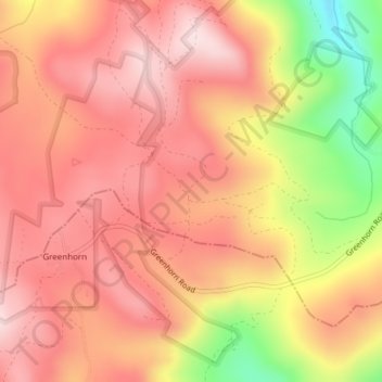
Name: Robinsonville topographic map, elevation, terrain.
Location: Robinsonville, Grant County, Oregon, United States (44.70376 -118.49467 44.72376 -118.47467)
Average elevation: 1,858 m
Minimum elevation: 1,632 m
Maximum elevation: 1,972 m
Other topographic maps
Click on a map to view its topography, its elevation and its terrain.
Granite
United States > Oregon > Grant County
Granite, Grant County, Oregon, United States
Average elevation: 1,475 m
Austin
United States > Oregon > Grant County
Austin, Grant County, Oregon, United States
Average elevation: 1,312 m
Monument
United States > Oregon > Grant County
Monument, Grant County, Oregon, United States
Average elevation: 640 m
Kimberly
United States > Oregon > Grant County
Kimberly, Grant County, Oregon, United States
Average elevation: 711 m
John Day
United States > Oregon > Grant County
John Day, Grant County, Oregon, 97845, United States
Average elevation: 1,047 m
Desolation Butte
United States > Oregon > Grant County
Desolation Butte, Grant County, Oregon, United States
Average elevation: 1,949 m
Rabbit Ears
United States > Oregon > Grant County
Rabbit Ears, Grant County, Oregon, United States
Average elevation: 2,285 m
Canyon City
United States > Oregon > Grant County
Canyon City, Grant County, Oregon, 97820, United States
Average elevation: 1,078 m
Prairie City
United States > Oregon > Grant County > Prairie City
Prairie City, Grant County, Oregon, United States
Average elevation: 1,104 m