
Canyon City topographic map
Interactive map
Click on the map to display elevation.
About this map
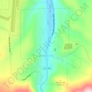
Name: Canyon City topographic map, elevation, terrain.
Location: Canyon City, Grant County, Oregon, 97820, United States (44.38124 -118.96065 44.40346 -118.93560)
Average elevation: 1,078 m
Minimum elevation: 955 m
Maximum elevation: 1,293 m
The city is at an elevation of about 3,200 feet (980 m). Between Canyon City and Burns, to the south, Route 395 passes through parts of the Malheur National Forest. According to the United States Census Bureau, the town has a total area of 1.41 square miles (3.65 km2), all land.
Other topographic maps
Click on a map to view its topography, its elevation and its terrain.
Granite
United States > Oregon > Grant County
Granite, Grant County, Oregon, United States
Average elevation: 1,475 m
Robinsonville
United States > Oregon > Grant County
Robinsonville, Grant County, Oregon, United States
Average elevation: 1,858 m
Austin
United States > Oregon > Grant County
Austin, Grant County, Oregon, United States
Average elevation: 1,312 m
Monument
United States > Oregon > Grant County
Monument, Grant County, Oregon, United States
Average elevation: 640 m
Kimberly
United States > Oregon > Grant County
Kimberly, Grant County, Oregon, United States
Average elevation: 711 m
John Day
United States > Oregon > Grant County
John Day, Grant County, Oregon, 97845, United States
Average elevation: 1,047 m
Desolation Butte
United States > Oregon > Grant County
Desolation Butte, Grant County, Oregon, United States
Average elevation: 1,949 m
Rabbit Ears
United States > Oregon > Grant County
Rabbit Ears, Grant County, Oregon, United States
Average elevation: 2,285 m
Prairie City
United States > Oregon > Grant County > Prairie City
Prairie City, Grant County, Oregon, United States
Average elevation: 1,104 m