
Panamkutty topographic map
Interactive map
Click on the map to display elevation.
About this map
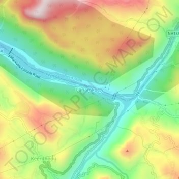
Name: Panamkutty topographic map, elevation, terrain.
Location: Panamkutty, Idukki, Idukki District, Kerala, 685562, India (9.93380 76.95502 9.97380 76.99502)
Average elevation: 513 m
Minimum elevation: 219 m
Maximum elevation: 906 m
Other topographic maps
Click on a map to view its topography, its elevation and its terrain.
Thoppipala
India > Kerala > Idukki > Labbakada
Thoppipala, Labbakada, Idukki, Idukki District, Kerala, 685511, India
Average elevation: 842 m
Panickankudy
Panickankudy, Idukki, Idukki District, Kerala, 685571, India
Average elevation: 758 m
Idukki reservoir
India > Kerala > Idukki > Ayyappancoil
Idukki reservoir, Ayyappancoil, Idukki, Idukki District, Kerala, India
Average elevation: 882 m
Kattappana
Kattappana, Idukki, Idukki District, Kerala, 688508, India
Average elevation: 950 m