
Thank you for supporting this site ❤️
Make a donation
Make a donation
Panickankudy topographic map
Click on the map to display elevation.
Thank you for supporting this site ❤️
Make a donation
Make a donation
About this map
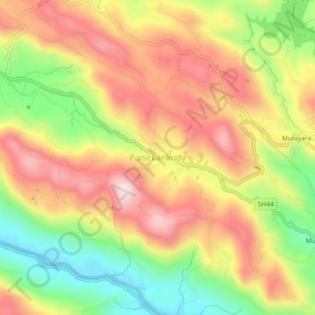
Name: Panickankudy topographic map, elevation, terrain.
Location: Panickankudy, Idukki, Idukki District, Kerala, 685571, India (9.90703 77.03632 9.94703 77.07632)
Average elevation: 758 m
Minimum elevation: 534 m
Maximum elevation: 954 m
Thank you for supporting this site ❤️
Make a donation
Make a donation
Other topographic maps
Click on a map to view its topography, its elevation and its terrain.