
德阳市 topographic map
Interactive map
Click on the map to display elevation.
About this map
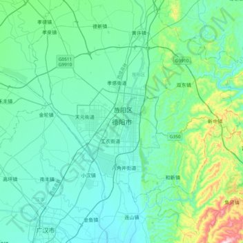
Name: 德阳市 topographic map, elevation, terrain.
Location: 德阳市, 旌阳区, 德阳市, 四川省, 中国 (30.96440 104.23013 31.28440 104.55013)
Average elevation: 534 m
Minimum elevation: 451 m
Maximum elevation: 994 m
德阳地形西高东低,西北部为山地,中部为平原,东南部为丘陵,属亚热带季风气候,四季分明,雨量充沛,年降雨量1000毫米左右,平均气温15.7-16.7℃。
Other topographic maps
Click on a map to view its topography, its elevation and its terrain.