
Ichemoul topographic map
Interactive map
Click on the map to display elevation.
About this map
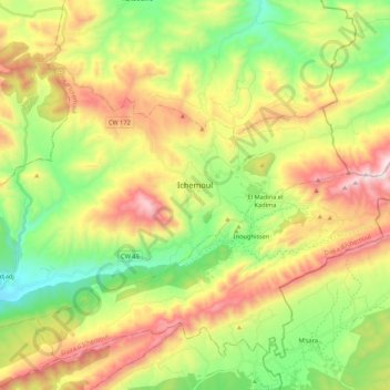
Name: Ichemoul topographic map, elevation, terrain.
Location: Ichemoul, Daïra Ichemoul, Batna, Algérie (35.24195 6.37968 35.36782 6.59497)
Average elevation: 1,559 m
Minimum elevation: 1,144 m
Maximum elevation: 2,142 m
Other topographic maps
Click on a map to view its topography, its elevation and its terrain.
Djebel Chélia
Algérie > Batna > Daïra Ichemoul > Inoughissen
Djebel Chélia, Inoughissen, Daïra Ichemoul, Batna, Algérie
Average elevation: 1,990 m
Inoughissen
Algérie > Batna > Daïra Ichemoul
Inoughissen, Daïra Ichemoul, Batna, Algérie
Average elevation: 1,575 m