
Inoughissen topographic map
Interactive map
Click on the map to display elevation.
About this map
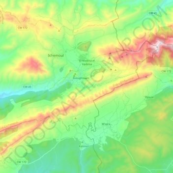
Name: Inoughissen topographic map, elevation, terrain.
Location: Inoughissen, Daïra Ichemoul, Batna, Algérie (35.23111 6.42212 35.32432 6.63867)
Average elevation: 1,575 m
Minimum elevation: 1,199 m
Maximum elevation: 2,316 m
Other topographic maps
Click on a map to view its topography, its elevation and its terrain.
Ichemoul
Algérie > Batna > Daïra Ichemoul
Ichemoul, Daïra Ichemoul, Batna, Algérie
Average elevation: 1,559 m
Djebel Chélia
Algérie > Batna > Daïra Ichemoul > Inoughissen
Djebel Chélia, Inoughissen, Daïra Ichemoul, Batna, Algérie
Average elevation: 1,990 m