
Barrow County topographic map
Interactive map
Click on the map to display elevation.
About this map
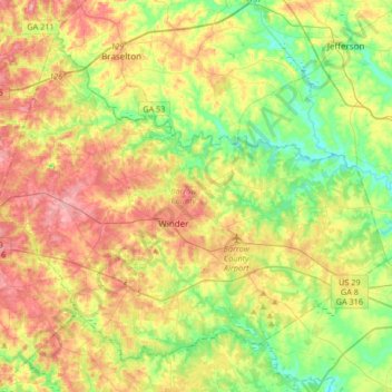
Name: Barrow County topographic map, elevation, terrain.
Location: Barrow County, Georgia, USA (33.89457 -83.86912 34.12752 -83.53653)
Average elevation: 261 m
Minimum elevation: 203 m
Maximum elevation: 334 m
Other topographic maps
Click on a map to view its topography, its elevation and its terrain.
Cameron Point
USA > Georgia > Cameron Point
Cameron Point, Hall County, Georgia, 30506:30534, USA
Average elevation: 339 m
Ferrell Crossroads
USA > Georgia > Ferrell Crossroads
Ferrell Crossroads, Early County, Georgia, USA
Average elevation: 94 m
Arabia Mountain
USA > Georgia > Stonecrest
Arabia Mountain, Stonecrest, DeKalb County, Georgia, 30058-8829, USA
Average elevation: 255 m