
Make a donation
Gaza Strip topographic map
Click on the map to display elevation.
Make a donation
Gaza Strip
The topography of the Gaza Strip is dominated by three ridges parallel to the coastline, which consist of Pleistocene-Holocene aged calcareous aeolian (wind deposited) sandstones, locally referred to as "kurkar", intercalated with red-coloured fine grained paleosols, referred to as "hamra". The three ridges are separated by wadis, which are filled with alluvial deposits.[132] The terrain is flat or rolling, with dunes near the coast. The highest point is Abu 'Awdah (Joz Abu 'Auda), at 105 meters (344 ft) above sea level.
Make a donation
About this map
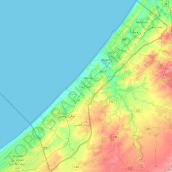
Name: Gaza Strip topographic map, elevation, terrain.
Location: Gaza Strip, Palestinian Territories (31.22013 34.21590 31.59685 34.56732)
Average elevation: 44 m
Minimum elevation: 0 m
Maximum elevation: 170 m
Make a donation
Other topographic maps
Click on a map to view its topography, its elevation and its terrain.
Sanur
Palestinian Territories > Area A
Sanur is located in the highlands of the northern West Bank. The village is situated on an isolated hilltop along the western edge of the valley and seasonal lake of Marj Sanur, which is named after the village. To the west, Sanur is connected to the Hawarah Ridge of the Zawiya Highlands through a low-lying…
Average elevation: 423 m