
Make a donation
Sanur topographic map
Click on the map to display elevation.
Make a donation
Sanur
Sanur is located in the highlands of the northern West Bank. The village is situated on an isolated hilltop along the western edge of the valley and seasonal lake of Marj Sanur, which is named after the village. To the west, Sanur is connected to the Hawarah Ridge of the Zawiya Highlands through a low-lying saddle. Mount Hureish, the tallest peak in the vicinity, is to the south. Part of the village is built on the descent toward the natural boundaries of the Marj Sanur valley. The old core of Sanur is on the hilltop and is mostly enclosed by walls that form part of the ruins of Sanur's former fortress. In 1979, the built-up areas of Sanur amounted to around 60 dunams. The average elevation of the village is 420 meters above sea level and it is about 45 meters higher than its immediate surrounding.
Make a donation
About this map
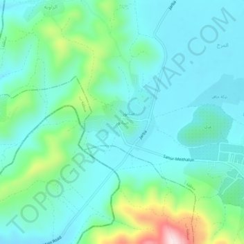
Name: Sanur topographic map, elevation, terrain.
Location: Sanur, Area A, West Bank, Palestinian Territories (32.33677 35.22587 32.37677 35.26587)
Average elevation: 423 m
Minimum elevation: 337 m
Maximum elevation: 743 m
Make a donation