
Make a donation
Garland Mountain topographic map
Click on the map to display elevation.
Make a donation
About this map
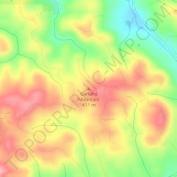
Name: Garland Mountain topographic map, elevation, terrain.
Average elevation: 379 m
Minimum elevation: 305 m
Maximum elevation: 440 m
Make a donation
Other topographic maps
Click on a map to view its topography, its elevation and its terrain.
Make a donation
Ball Ground
United States > Georgia > Cherokee County
According to the United States Census Bureau as of 2020, Ball Ground has a total area of 6.3 sq mi (16 km2), of which 0.04 sq mi (0.10 km2), or 0.63%, is water. The city's elevation averages around 1,100 ft (340 m) above sea level, ranging from just over 1,000 ft (300 m) in the valleys to around 1,200 ft (370…
Average elevation: 331 m
Make a donation