
Thank you for supporting this site ❤️
Make a donation
Make a donation
Lac des Sittelles topographic map
Click on the map to display elevation.
Thank you for supporting this site ❤️
Make a donation
Make a donation
About this map
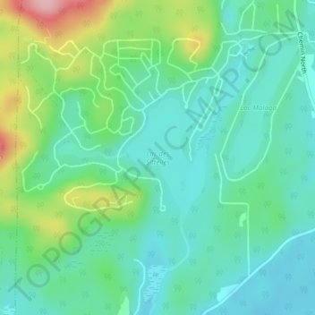
Name: Lac des Sittelles topographic map, elevation, terrain.
Location: Lac des Sittelles, Austin, Memphrémagog, Québec, Canada (45.24139 -72.27503 45.25344 -72.26511)
Average elevation: 315 m
Minimum elevation: 270 m
Maximum elevation: 438 m
Thank you for supporting this site ❤️
Make a donation
Make a donation
Other topographic maps
Click on a map to view its topography, its elevation and its terrain.