
Thank you for supporting this site ❤️
Make a donation
Make a donation
Mangan topographic map
Click on the map to display elevation.
Thank you for supporting this site ❤️
Make a donation
Make a donation
About this map
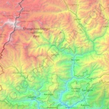
Name: Mangan topographic map, elevation, terrain.
Location: Mangan, Mangan District, Sikkim, India (27.37542 88.11250 27.68599 88.80824)
Average elevation: 3,312 m
Minimum elevation: 373 m
Maximum elevation: 8,521 m
Thank you for supporting this site ❤️
Make a donation
Make a donation
Other topographic maps
Click on a map to view its topography, its elevation and its terrain.
Thank you for supporting this site ❤️
Make a donation
Make a donation
Thank you for supporting this site ❤️
Make a donation
Make a donation