
Basilan topographic map
Click on the map to display elevation.
Basilan
Basilan National Park is at the eastern portion of the remaining public forest between the city of Isabela and the municipalities of Lamitan, Tipo-Tipo and Sumisip. The park has an elevation of 971 metres (3,186 ft) above sea level, and the tallest peak, Puno Mahaji or Basilan Peak, dominates the park's landscape.
About this map
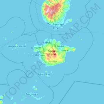
Name: Basilan topographic map, elevation, terrain.
Location: Basilan, Bangsamoro, Philippines (6.15700 121.26171 7.01779 122.54167)
Average elevation: 32 m
Minimum elevation: -2 m
Maximum elevation: 1,299 m
Other topographic maps
Click on a map to view its topography, its elevation and its terrain.
Mount Mayon
Philippines > Albay > Tabaco
On February 23, 2023, a twin engine Cessna 340 airplane owned by the Energy Development Corporation departed Bicol International Airport in the early morning on an executive flight to the capital Manila. A few minutes after takeoff, while climbing to an altitude of 6,000 ft (1,800 m), it impacted the rocky…
Average elevation: 1,696 m