
Virginia topographic map
Interactive map
Click on the map to display elevation.
About this map
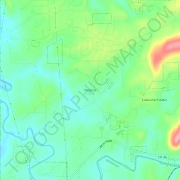
Name: Virginia topographic map, elevation, terrain.
Location: Virginia, Hueytown, Jefferson County, Alabama, United States (33.38900 -87.07055 33.42900 -87.03055)
Average elevation: 146 m
Minimum elevation: 111 m
Maximum elevation: 226 m
Other topographic maps
Click on a map to view its topography, its elevation and its terrain.
Bush
United States > Alabama > Jefferson County > Hueytown
Bush, Hueytown, Jefferson County, Alabama, 35061, United States
Average elevation: 170 m