
Covasna topographic map
Interactive map
Click on the map to display elevation.
About this map
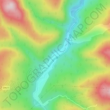
Name: Covasna topographic map, elevation, terrain.
Location: Oituz, Covasna, Romania (46.07093 26.38749 46.07453 26.39450)
Average elevation: 752 m
Minimum elevation: 603 m
Maximum elevation: 950 m
Other topographic maps
Click on a map to view its topography, its elevation and its terrain.
Bucharest
The city has an area of 226 km2 (87 sq mi). The altitude varies from 55.8 m (183.1 ft) at the Dâmbovița bridge in Cățelu, southeastern Bucharest and 91.5 m (300.2 ft) at the Militari church. The city has a roughly round shape, with the centre situated in the cross-way of the main north–south/east-west…
Average elevation: 82 m