
旱河 topographic map
Interactive map
Click on the map to display elevation.
About this map
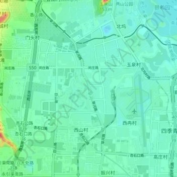
Name: 旱河 topographic map, elevation, terrain.
Location: 旱河, 海淀区, 北京市, 100094, 中国 (39.93894 116.21678 39.99224 116.25227)
Average elevation: 58 m
Minimum elevation: 44 m
Maximum elevation: 119 m
Other topographic maps
Click on a map to view its topography, its elevation and its terrain.
北京西山国家森林公园
北京西山国家森林公园, 红枫路, 香山街道, 南辛村, 海淀区, 北京市, 100094, 中国
Average elevation: 247 m