
Haryana topographic map
Interactive map
Click on the map to display elevation.
About this map
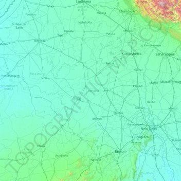
Name: Haryana topographic map, elevation, terrain.
Location: Haryana, India (27.65607 74.46520 30.93024 77.59509)
Average elevation: 281 m
Minimum elevation: 170 m
Maximum elevation: 3,390 m
Other topographic maps
Click on a map to view its topography, its elevation and its terrain.
Hisar
Hisar is located at 29°05′N 75°26′E / 29.09°N 75.43°E / 29.09; 75.43 in western Haryana. It has an average elevation of 215 m (705 ft) above sea level. The region is part of the alluvial Ghaggar-Yamuna plain and its southern and western portions mark a gradual transition to the desert. The…
Average elevation: 213 m