
Thank you for supporting this site ❤️
Make a donation
Make a donation
Matlauda topographic map
Click on the map to display elevation.
Thank you for supporting this site ❤️
Make a donation
Make a donation
About this map
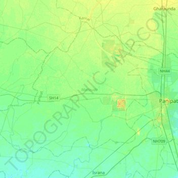
Name: Matlauda topographic map, elevation, terrain.
Location: Matlauda, Panipat, Haryana, 132113, India (29.30324 76.64761 29.53397 76.96912)
Average elevation: 237 m
Minimum elevation: 229 m
Maximum elevation: 250 m
Thank you for supporting this site ❤️
Make a donation
Make a donation
Other topographic maps
Click on a map to view its topography, its elevation and its terrain.
Hisar
Hisar is located at 29°05′N 75°26′E / 29.09°N 75.43°E / 29.09; 75.43 in western Haryana. It has an average elevation of 215 m (705 ft) above sea level. The region is part of the alluvial Ghaggar-Yamuna plain and its southern and western portions mark a gradual transition to the desert. The…
Average elevation: 213 m