
Ramdane Djamel topographic map
Interactive map
Click on the map to display elevation.
About this map
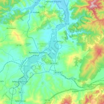
Name: Ramdane Djamel topographic map, elevation, terrain.
Location: Ramdane Djamel, Daïra Ramdane Djamel, Skikda, 21425, Algérie (36.70204 6.80456 36.80946 7.03121)
Average elevation: 158 m
Minimum elevation: 7 m
Maximum elevation: 652 m
Other topographic maps
Click on a map to view its topography, its elevation and its terrain.
Beni Bechir
Algérie > Skikda > Daïra Ramdane Djamel
Beni Bechir, Daïra Ramdane Djamel, Skikda, Algérie
Average elevation: 98 m