
汝城县 topographic map
Interactive map
Click on the map to display elevation.
About this map
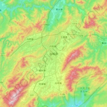
Name: 汝城县 topographic map, elevation, terrain.
Location: 汝城县, 郴州市, 湖南省, 中国 (25.37585 113.52140 25.69585 113.84140)
Average elevation: 684 m
Minimum elevation: 181 m
Maximum elevation: 1,599 m
汝城山地面积广阔,气候和土地适宜发展林业,目前是湖南省重要的林业基地之一,森林覆盖率达72%。由于具备充沛的降雨和较高的地形落差,水能蕴藏量也很丰富,近年以来小水电项目发展迅速。县境内有丰富的可开采矿藏资源,其中以钨、铁、煤和石灰石的产量最大,钨矿等矿产加工业已成为主要的工业支柱。
Other topographic maps
Click on a map to view its topography, its elevation and its terrain.